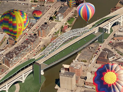
The 2012 Cleveland Design Competition asked participants to transform the Lower Level of the Veterans Memorial Bridge, a nearly one-mile long, century-old steel structure spanning the Cuyahoga River and connecting Cleveland's West Side with Downtown.
Initially one of the country's few two-level bridges, it was also one of the busiest, with cars and trucks traversing the Upper Level and passenger trolleys running below. With trolley service suspended in the mid-1950's, the Lower Level tracks and subterranean platforms and passageways below the streets were all but abandoned, save for temporary openings during special events or festivals.
Project Team: Luke Amey, P.E.; Rodrigo Balarezo; Antoinette Belson; James Gdovin; Richard Lucas
Our vision for transforming the bridge is more than an isolated intervention at the Lower Level. It extends beyond the substructure of the Bridge to encompass the entire landscape and adjacent neighborhoods, including the River and Valley below.
Our objectives were: To enhance and engage the surrounding communities; Create a stronger relationship and physical connection to the Cuyahoga River, Towpath and Canal Basin; Invent a unique, iconic, and highly visible landmark for the city; And provide a flexible environment for multiple experiences and activities to occur or be planned.
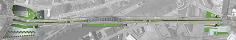
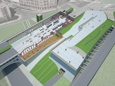
A.New Cuyahoga County Engineers Building
B.History of Transit Museum (Lower Level)
C.Fitness Path Entrance (Lower Level)
D.Entry Towers to Lower Level
E.West Access Plaza and Memorial Park
F.Fitness Path (Lower Level)
|
|
G.West & East Overpass
H.Elevated Walkway (Lower Level)
I.Mid-Span Valley Overlook
J.East Access Plaza
K.New Vehicular Traffic Lane
L.'Green Ribbon' Median
|
Inspired by local History, Geography, Industry and Culture, we've proposed several interventions over the entire site, including manipulation of the landscape and upper roadway through a variety of plazas, ramps, sloped grassland ribbons and lawn-covered garden overlooks.
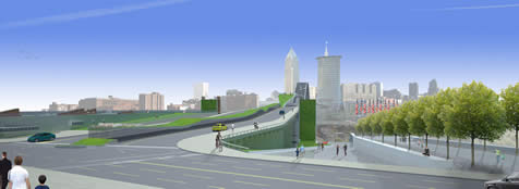
The west approach, seen above, includes, from left to right: A new County Engineers Facility with an accessible green-roof; vehicular access to the Upper Level roadway; an open-air market Plaza sloping downward for access to the Lower Level; and at the far right, a Memorial Park and garden honoring area veterans. Flanking the roadway beyond are two towers with living green-walls providing covered access to the Lower Level and marking the entry when seen from the sidewalks, surrounding neighborhoods and roadway above.
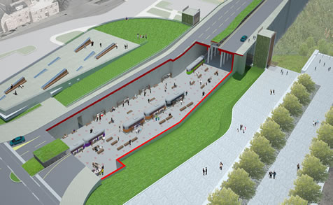
Below the Upper Level roadway of the west approach, in an area known as the catacombs, we've incorporated a Transit History Museum, shown in the drawing above with the upper roadway removed. Also visible here is the green roof of the new County Engineers Facility on the upper left, and the sloped, open-air market Plaza and Memorial Park to the right.
The East Access, shown above, includes, from left to right, an underground parking garage with a sloped recreational lawn and amphitheater above; a "Splash Park" with monolithic stone slabs and digitally programmed fountains; a sloped Plaza providing access to the Lower Level below the roadway; and extruded above the roadway is the Grassland Ribbon, providing additional light to the Lower Level.
As in the West Access, the east side also includes two living green-wall towers flanking the roadway, with additional access to the Lower Level provided by a stairway located below the Grassland Ribbon.
In this view, the upper roadway of the East Access is peeled away to reveal the Lower Level Market Space, a Fine Dining Restaurant, the Juice Bar and Fitness Path, as well as Storage, Restrooms and Administrative spaces.
The outdoor Dining Terrace, Splash Park and Amphitheater are at the higher elevation to the right, with the Grassland Gardens and paved access path sloping down to the underground parking entrance on the lower elevation.
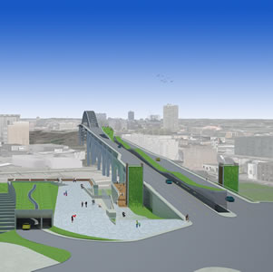
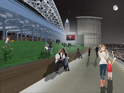
Two of the more dramatic features of our proposal for transforming the bridge are visible in this aerial view.
First is a new recreational park and overlook located on the south side of the bridge at mid-span. The green space, nearly 50' x 600', with an additional 50' of boardwalk space to the east and west of the lawn, would be suspended from two towers anchored on the East and West banks of the River that also provide elevator and stairway access to the fitness and scenic paths along the River, some 100' below the Bridge.
Projecting over the roadway on either side of the mid-span structure are two elongated green spaces that emerge from the Lower Level and ramp up toward the center span to an elevation of 20' over the roadway. High above the Cuyahoga Basin, these 'Overpasses' provide a unique perspective of the Bridge and skyline beyond, while also offering needed green space within the industrial and manufacturing area more commonly known as 'The Flats'.
A night view of the Mid-Span Overlook illustrates its potential use for evening venues including outdoor film screenings, exhibition openings, fashion premiers, recreational sports and family gatherings, or just a simple, romantic walk in the moonlight.
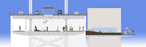
This section through the bridge at mid-span shows the Upper Level roadway for vehicles with the raised, "green ribbon" opening in the center of the roadway allowing additional light onto activity at the Boardwalk Level below.
On the Lower Level, from left to right, the section illustrates: The Fitness Path; Elevated Walkway and Boardwalk with structural glazing floor planks looking to below, display panels and vendor table plug-in accessories; and the Mid-Span Overlook park at the far right with the anchor towers visible in the background.
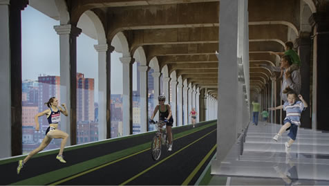
The Fitness Path would be installed along the northern concourse of the bridge with access ramps adjacent to the Lower Level Entry Towers on both the east and west sides of the bridge.
The Elevated Walkway, with structural glazing floor panels providing views to the substructure and river below, would be suspended from existing beams on one end, and cantilevered outward from structure supported by the central portion of the Boardwalk on the other.
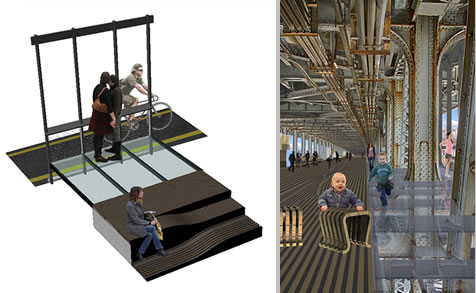
The axonometric view illustrates the relationship between the Fitness Path and Elevated Walkway, with the structural glazing floor planks and, in the foreground, a system of short ramps connecting the Boardwalk Level to the Elevated Walkway. The railings at the Walkway would be outfitted with didactic, low-relief bronze plaques describing the geographical, manufacturing and river transport history of the region and Cuyahoga River Basin.
The perspective view shows the elevated walkway from within the center structure of the Bridge looking west. The mobile stools and 'plug-in' vendor tables and display panels designed as part of our proposal are visible in the background.
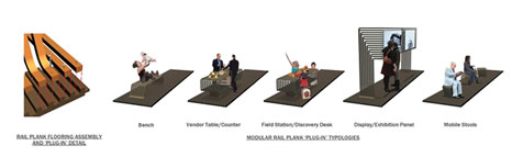
Any serious proposal for activating and transforming the Lower Level of the bridge should provide a durable, comfortable walking surface above the steel and concrete deck of the bridge structure. We also believe it's important for this surface to offer flexibility in terms of the activities and events that could be planned for the Lower Level Boardwalk.
Accordingly, we devised a custom-fabricated system of extruded, recycled rubber floor planks with continuous grooves that would be in-filled with removable wood strips. These strips could be replaced with a variety of 'plug-in' accessories such as benches, vendor tables and counters, field station 'discovery desks', and display panels. This 'Plug-in' furniture allows a multitude of programming events from Farmer's Markets, Science Fairs and Crafts Festivals, to Fine Arts and cultural exhibits, runway Fashion Premiers and a variety of other activities.
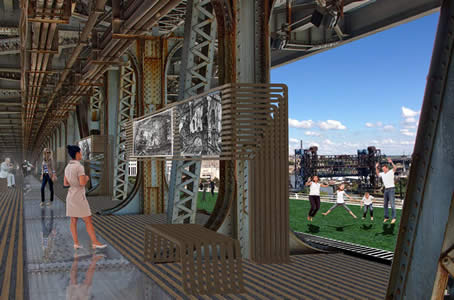
This view, from the center of the bridge looking south-east, shows the structural glazing floor panels and the extruded, recycled rubber floor plank system with 'plug-in' display panels and bench furniture. In the distance can be seen the green space of the Mid-Span Overlook and views of other bridges spanning the river basin and connecting the city beyond.
Providing a unique 'sky-garden' with spectacular views of the Memorial Bridge center span and Downtown Cleveland beyond, this view of the recreational lawn atop the West Overpass, illustrates the benefit of extending the Competition site beyond the limits of the Lower Level.
The benefits of introducing landscape elements and green space in such an overwhelmingly industrial context becomes apparent and, in a singular view, exemplifies several of our initial goals and captures the spirit of our overall concept for transforming the bridge.
|